

About Malda District
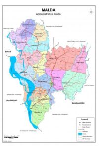
Malda district (also spelt as Maldaha or Maldah) covers an area of 3,733 sq. km, representing 4.7% of West Bengal’s total land area and housing 4.1% of the state’s population. Geographically positioned between 24°40’20” and 25°32’8” N latitudes and 87°45’50” to 88°28’10” E longitudes, the district occupies a strategic boundary location. It is bordered by Murshidabad district to the south, Uttar Dinajpur district to the north, Bangladesh to the east, Bihar to the west, Dakshin Dinajpur district to the northeast, and Jharkhand to the southwest.
Demographics & Administrative Setup
Total Population
3,988,845
As per Census 2011
Gender Distribution
Male: 2,051,541 (51.43%)
Female: 1,193,7304 (48.56%)
Sex Ratio: 940
Population Split
Rural: 3,447,185 (86.42%)
Urban: 541,660 (13.57%)
The district headquarters is located in English Bazar. For administrative convenience, Malda is split into two major subdivisions—Malda Sadar and Chanchal—spanning 15 blocks (Harishchandrapur-I & II, Chanchal-I & II, Ratua-I & II, Gazole, Bamongola, Habibpur, Old Malda, English Bazar, Manikchak, and Kaliachak-I, II & III) alongside 1,613 villages.
Operational Area of the KVK
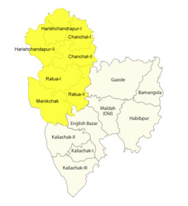
While there are two KVKs present within Malda district, their distinct operational territories are clearly demarcated. The Malda KVK managed under the Uttar Banga Krishi Viswavidyalaya (UBKV) handles all agricultural and extension development frameworks across the entire Chanchal subdivision, alongside the Manikchak block belonging to the Malda Sadar subdivision.
Consequently, Malda KVK focal program deployment concentrates within these 7 specific blocks: Ratua-I & II, Chanchal-I & II, Harishchandrapur-I & II, and Manikchak (highlighted in yellow on the territorial map layout).
Agriculture Landscape
The economy of Malda is fundamentally agrarian, serving as the main source of income for over 90% of the rural population. According to the Agricultural Census, small and marginal farms account for 95.6% of holdings and cover 58.07% of the total farmland, keeping regional production tightly balanced between subsistence farming and emerging commercial enterprise. Principal crops harvested include wheat, paddy, jute, various rabi options, mangoes, and raw silk.
Physiographic Agro-Zones
Physiographically, the district is categorized into three distinct agro-ecological zones:
- Tal Region: Low-lying terrain highly prone to annual monsoon inundation. Soil profiles feature deep loam to clay-loam properties. This zone contains six core blocks: Harishchandrapur-I & II, Ratua-I & II, and Chanchal-I & II.
- Barind Region: High-altitude flat plains with sparse perennial open water resources. Features old alluvial soil bases shifting from clay to heavy clay loam. It encompasses Gazole, Bamongola, Habibpur, and Old Malda blocks.
- Diara Region: Generally flat terrains moving down the western borders, carrying highly fertile topsoils ranging across sandy loam, clay loam, pure loam, and silt loam variants. It spans the remaining five blocks.
Key Agricultural Metrics
| Geographical Area | Gross Cropped Area | Net Cropped Area | Gross Irrigated Area | Net Irrigated Area | Cropping Intensity | Primary Cropping Patterns |
|---|---|---|---|---|---|---|
| 370.8k ha | 474.7k ha | 260.0k ha | 459.83k ha | 125.13k ha | 196% |
• Jute – Paddy – Wheat • Jute – Pulses • Maize – Paddy – Mustard • Maize – Wheat / Pulses |
Climate & Weather Profiles
Monthly Average Rainfall
| Month | Rainfall (mm) |
|---|---|
| January | 5.22 |
| February | 16.16 |
| March | 18.00 |
| April | 76.64 |
| May | 121.64 |
| June | 155.98 |
| July (Peak) | 342.02 |
| August | 240.58 |
| September | 270.66 |
| October | 93.08 |
| November | 0.00 |
| December | 3.86 |
| Annual Total | 1,343.84 mm |
Monthly Average Temperature
| Month | Max Temp (°C) | Avg Temp (°C) |
|---|---|---|
| January | 24.2 | 17.4 |
| February | 26.8 | 19.7 |
| March | 32.7 | 25.0 |
| April (Peak) | 36.1 | 29.1 |
| May | 35.6 | 30.1 |
| June | 33.6 | 29.7 |
| July | 31.8 | 28.9 |
| August | 31.6 | 28.8 |
| September | 31.8 | 28.8 |
| October | 31.0 | 26.9 |
| November | 27.9 | 21.8 |
| December | 25.2 | 18.7 |